
Laser-accurate existing drawings of your Barking and Dagenham property — floor plans, elevations and sections measured on site and drawn to millimetre tolerance, so every design, planning application and lease that follows starts from a base that is actually right, delivered in days.
Barking and Dagenham Council granted 84% of the householder planning decisions it made in its latest published year — 3 points below the 87% England-wide householder average. The Becontree Estate's uniform garden-suburb layout means front alterations and roof changes are assessed against the whole street's consistency, which is where a policy-literate drawing pack earns its keep. Its dominant Victorian (1837–1901), Edwardian (1901–1910), interwar (1918–1939) and postwar (1945–1970) housing stock sets the design brief on most streets.
Class A and Class B set the thresholds — a rear dormer to 40m³ on a terrace or 50m³ on a semi or detached, and a single-storey rear extension to 3m on a terrace or 4m on a detached house — beyond which Barking and Dagenham Council needs a full application. Barking and Dagenham carries at least one Article 4 direction, and conservation areas including Barking Town Centre (Abbey), Becontree Estate and Chadwell Heath remove those rights outright, so we confirm your exact address before a line is drawn. A validated householder application in Barking and Dagenham is determined against an 8-week statutory target.
Barking (older terraces and flats around the Abbey and town-centre conservation area), Dagenham (the planned interwar Becontree cottage estate of semis and short terraces), Chadwell Heath (interwar suburban housing with a small conservation area), Becontree (uniform 1920s-30s garden-suburb streets on the huge municipal estate), Rush Green (interwar semis on the borough's eastern edge) and Marks Gate (postwar estate housing to the north) — these are the Barking and Dagenham pockets our drawings cover most. Heritage designations here include Barking Town Centre (Abbey), Becontree Estate, Chadwell Heath, Eastbury and Barking Abbey. Barking and Dagenham Council weighs each proposal against Barking and Dagenham Local Plan 2037 and the borough's residential design guidance, where generous original plots make rear and side extensions viable but officers guard the estate's spacing and building lines. On roofs the borough is hipped roofs on the cottage-estate semis and gabled roofs on the older terraces, over interwar Becontree cottage-estate semis and short terraces, Victorian and Edwardian terraces around Barking and postwar and modern infill.
Every proposed drawing is really two drawings — the house as it is, and the house as it will be — and the second is only as good as the first. A measured survey captures the property as-built: room sizes, wall thicknesses, window and door positions, floor-to-floor heights, ceiling lines and the outside envelope, all cross-checked so the plans, elevations and sections agree. Barking and Dagenham's interwar Becontree cottage-estate semis and short terraces, Victorian and Edwardian terraces around Barking and postwar and modern infill are rarely square or standard — walls lean, floors step, bays and returns hide behind later work — so measuring by hand off an old estate-agent plan simply carries the errors forward.
We survey with a laser measure and, on larger or more complex Barking and Dagenham buildings, a scanner that captures a point cloud — millions of measured points the drawings are traced from — so nothing is estimated. The output is a clean set of scaled as-existing drawings, delivered in CAD, that an architect, engineer or lease-plan draughtsman can work straight into. The Becontree Estate's uniform garden-suburb layout means front alterations and roof changes are assessed against the whole street's consistency, and an accurate existing set is what lets the proposed scheme answer that without a mid-project surprise.
Period and listed stock — the kind found across Barking Town Centre (Abbey), Becontree Estate, Chadwell Heath, Eastbury and Barking Abbey and Barking and Dagenham's other conservation areas — is exactly where survey accuracy matters most, because heritage detail, irregular geometry and past alterations all have to be recorded faithfully. The vast Becontree cottage estate is a heritage asset in its own right, and Article 4 controls apply in parts of the borough to protect the estate's consistent frontages and the historic core around Barking Abbey. We capture the fabric as it really is so the record stands up to scrutiny.

A measured survey is worth its cost whenever an accurate existing record matters. For Barking and Dagenham properties that usually means one of these:
We measure the whole property on site — plans, elevations, sections, floor-to-floor heights and the external envelope — and deliver a clean, scaled as-existing CAD set that your architect, engineer or lease draughtsman can build straight onto, so no one is re-measuring halfway through the Barking and Dagenham project.
Below is Barking and Dagenham Council's real householder decision record, drawn from official planning statistics and refreshed as new data lands. Barking and Dagenham grants a fair majority of householder applications, with the design consistency of the Becontree cottage estate the defining constraint across much of the borough. A measured survey never appears in these figures, but it sits behind the applications that do — an accurate existing set is the difference between a scheme that is decided on merit and one queried because the drawings do not add up.
Source: MHCLG planning application statistics (householder decisions, rolling year). Compare every borough on our London approval-rate league table.
Tell us about your project and get a fixed, no-obligation quote back within one working day. If you don't need planning permission at all, we'll tell you that too — for free.
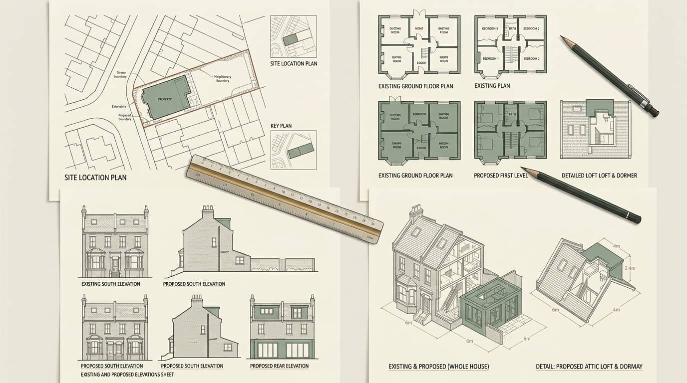
The deliverable is a coordinated set: existing floor plans for every level, elevations of each face, and at least one section cut through the building to show floor-to-floor and ceiling heights — the dimension a plan alone can never carry. Everything is drawn to a stated scale and tolerance and issued as CAD, so it drops straight into the next stage. Across Barking, Dagenham and Chadwell Heath, the buildings that most reward this are the large and altered ones, where a wrong assumption about a wall or a level costs a redesign later.
Generous original plots make rear and side extensions viable but officers guard the estate's spacing and building lines. We cross-check every dimension on site so the plans, elevations and sections agree with each other and with the real Barking and Dagenham building — the discipline that stops a proposed extension being drawn against a wall that is not where the old plan said it was.

We survey houses, flats and mixed-use buildings across the borough. A few of the Barking and Dagenham neighbourhoods where measured surveys come up most often:
Measured surveys of Barking's older terraces and flats around the Abbey and town-centre conservation area — laser-measured, cross-checked and delivered as scaled as-existing CAD.
Measured surveys of Dagenham's the planned interwar Becontree cottage estate of semis and short terraces — laser-measured, cross-checked and delivered as scaled as-existing CAD.
Measured surveys of Chadwell Heath's interwar suburban housing with a small conservation area — laser-measured, cross-checked and delivered as scaled as-existing CAD.
Measured surveys of Becontree's uniform 1920s-30s garden-suburb streets on the huge municipal estate — laser-measured, cross-checked and delivered as scaled as-existing CAD.
Measured surveys of Rush Green's interwar semis on the borough's eastern edge — laser-measured, cross-checked and delivered as scaled as-existing CAD.
Measured surveys of Marks Gate's postwar estate housing to the north — laser-measured, cross-checked and delivered as scaled as-existing CAD.
A full survey records the property in three dimensions, not one. This is what each output gives and what it is used for.
| Output | What it records | Used for | Typical method |
|---|---|---|---|
| Existing floor plans | Room sizes, wall thicknesses, openings | Design, planning, lease plans | Laser measure |
| Elevations | Each external face, window positions, heights | Planning applications, heritage | Laser & photo |
| Sections | Floor-to-floor and ceiling heights | Loft, structural, headroom checks | Laser & scan |
| Point cloud | Millions of measured points | Complex or large buildings | 3D laser scanner |
On period and listed stock around Barking Town Centre (Abbey) and Becontree Estate, a point-cloud survey records irregular Barking and Dagenham fabric that hand measurement would miss.
A fixed process built around getting the existing record right first time — most as-existing sets are delivered within five days of the site visit.
Tell us the Barking and Dagenham property type and what the survey is for. We confirm what you need — plans only, or plans, elevations and sections — and whether a scan is worth it for the building's size or complexity.
A surveyor measures the whole property with a laser measure and, where useful, a 3D scanner — every room, the external envelope, floor-to-floor heights and the awkward corners an old plan glosses over.
We draw up the coordinated existing plans, elevations and sections to a stated scale and tolerance and issue them as CAD, ready for the next stage of your Barking and Dagenham project.
You get the full set in CAD and PDF, and we answer any query from the architect, engineer or Barking and Dagenham Council that follows — the survey is the base everything else is checked against.
No — a measured survey is simply an accurate record of the property as it stands, so it needs no permission from Barking and Dagenham Council and involves no building work. It is the step before any application: the as-existing drawings it produces become the base for the proposed scheme you later submit. Many Barking and Dagenham projects go wrong precisely because they skip it and design onto an inaccurate old floorplan instead.
They answer completely different questions. A valuation or condition survey tells you what a Barking and Dagenham property is worth or what state it is in; a measured building survey tells you precisely what shape and size it is — the dimensions an architect or engineer needs to draw from. If you are extending, converting or applying to Barking and Dagenham Council, it is the measured survey you need, not a valuation.
You can, and for a small square room it is fine — but Barking and Dagenham's interwar becontree cottage-estate semis and short terraces are rarely square, and small errors compound across a whole building until the plans, elevations and sections no longer agree. A laser or scanned survey cross-checks every dimension so the set is internally consistent. The cost is modest against a redesign, or an application Barking and Dagenham Council queries because the drawings do not match the building.
A full measured survey includes all three. Floor plans alone cannot tell you floor-to-floor or ceiling heights, which is exactly what a loft conversion, a structural calculation or a headroom check in a Barking and Dagenham property depends on. We record elevations of each external face and cut at least one section through the building, so the existing set is complete and every later stage has the dimension it needs. Barking and Dagenham Council is the decision-maker.
Yes — an accurate measured survey is the ideal base for both. A Land Registry-compliant lease plan is drawn from the same existing measurements, and a party wall surveyor works from an accurate record of the Barking and Dagenham property and its boundaries. Commissioning one survey that serves the design, a lease plan and any party wall work avoids paying to measure the building more than once. Barking and Dagenham Council is the decision-maker.
We price each Barking and Dagenham survey on the size of the property and whether you need plans only or plans, elevations and sections, and send a fixed, no-obligation quote within one working day. Larger or listed buildings that warrant a 3D scan are quoted accordingly. The survey pays for itself by keeping every later drawing and Barking and Dagenham Council submission accurate. Call 020 7864 7245 to start.
Answer five quick questions and get a free planning score for your exact address — instantly. Then, if you want the full picture, unlock the detailed analysis: your council's live approval rates, local precedents, constraints on your street and a step-by-step route to permission.
Same fixed quotes, same fast drawings — wherever your project is.