Planning application drawings drawn to be approved, not just submitted
London councils decided 24,758 householder applications last year and granted 85.6% of them. The drawings decide which side of that line you land on — and, just as often, whether the application is validated at all.
★★★★★ Rated 4.9/5 by London homeowners96% approval rate · 2,400+ drawings delivered
Share
What every London householder application must contain
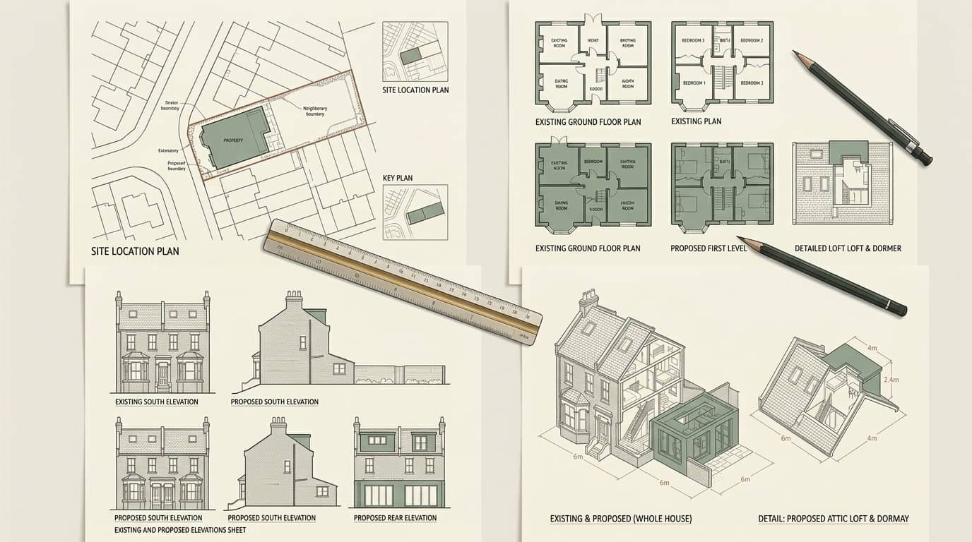
Councils publish their own validation lists and they differ at the margins, but the core is common to all 33 boroughs. A pack missing any of these is not refused — it is simply not validated, and the statutory period does not begin.
Drawing
Scale
What it has to show
Location plan
1:1250
The site edged red, adjoining land in the applicant's control edged blue, at least two named roads, and a north point
Site or block plan
1:200 or 1:500
The property in its plot with boundaries, existing and proposed footprints, hardstanding and parking
Existing floor plans
1:50 or 1:100
Every affected floor as built, including the rooms the proposal does not alter
Proposed floor plans
1:50 or 1:100
The same floors as intended, with new structure, openings and room uses labelled
Existing and proposed elevations
1:50 or 1:100
Every elevation affected — commonly all four — with materials annotated
Sections
1:50 or 1:100
Required where roof form, floor levels or ground levels change; always for a loft conversion
Common requirements across the 33 London borough validation lists. Individual councils may also require a design and access statement, heritage statement or biodiversity information depending on the site.
Why applications fail, and why it is rarely the design
London's householder approval rate is 85.6% — 21,185 grants from 24,758 decisions in the last full year — against 90.3% across England. Roughly one application in seven is refused, and the reasons cluster: loss of neighbour amenity, harm to the character of a conservation area, and overdevelopment of the plot.
None of those is a drawing error. What drawings do is decide whether the officer can assess the scheme at all. A section that omits the neighbouring boundary leaves the amenity question open; elevations without annotated materials leave the character question open; a floor plan that does not show the original rear wall leaves the officer unable to confirm which permitted development allowance has already been used.
An officer with an open question either asks it — which costs weeks — or resolves it against the applicant. Both outcomes are avoidable at drawing stage, and both are far more common than a genuinely unacceptable design.
Approval is not the same across London
The borough deciding your application changes your odds more than most homeowners expect. These are the extremes from the last full financial year, on the same MHCLG definitions.
Borough
Householder approval rate
Householder decisions
Hammersmith and Fulham
98.6%
560
Bexley
95.3%
939
Kensington and Chelsea
94.3%
574
London average
85.6%
24,758
Bromley
79.0%
1,538
Greenwich
77.6%
647
Barking and Dagenham
68.0%
406
MHCLG district planning application statistics (PS1/PS2), financial year 2025-26, householder developments. England-wide average 90.3% across 310 local planning authorities. Derived in scripts/aggregate/ps1_ps2.py.
Do you need a planning application at all?
Many London projects do not. Permitted development rights let you build without applying, provided the property is a house rather than a flat and the work stays inside the limits. You need a full application where:
The property is a flat or maisonette — Part 1 permitted development rights apply to houses only
A rear extension exceeds 3m from the original rear wall on a semi-detached or terraced house, or 4m on a detached one
A loft conversion exceeds 40m³ on a terrace or 50m³ on a semi or detached house, raises the ridge, or places a dormer on the front roof slope
The property is in a conservation area and the work affects a side elevation, the roof, cladding or windows
An Article 4 direction applies to the property, removing the permitted development rights that would otherwise cover the work
The building is listed, in which case listed building consent is needed as well as, and separately from, planning permission
Ready for drawings your council will approve?
Tell us about your project and get a fixed, no-obligation quote back within one working day. If you don't need planning permission at all, we'll tell you that too — for free.
How we prepare an application
The sequence is designed around validation: the fastest route to a decision is a pack the council can accept on the day it arrives.
1
Free approval check
Conservation area, Article 4 direction and listed status for your address, and an honest answer on whether you need an application at all. Where the project is permitted development we will say so rather than sell you one.
2
Measured survey
An accurate record of the building as it stands and, so far as the records allow, as originally built. Permitted development allowances run from the original house, and previous extensions are the most common reason a project turns out to need permission.
3
Drawings to the borough's validation list
Plans, elevations, sections, site plan and location plan at the scales your council requires, with materials annotated and the neighbouring relationship drawn — so the officer's questions are answered on the sheet.
4
Submission and case-officer liaison
We submit through the Planning Portal, respond to the officer, and revise the drawings free of charge until your council issues its decision.
Planning permission is not the only consent you may need
Planning permission and party wall consent are separate statutory regimes, and getting one grants you nothing under the other. Planning is decided by the council under the Town and Country Planning Act; party wall matters are decided between you and your neighbour under the Party Wall etc. Act 1996, with no council involvement at all. If your extension will cut into a shared wall, build astride the boundary, or excavate within three metres of a neighbouring structure and deeper than its foundations, you must serve notice — whether or not you also need planning permission. Our party wall surveying service covers that side.
85.6% London approval rate
8 weeks Statutory period
24,758 Decisions in 2025-26
Frequently asked questions
What drawings are required for a planning application?
A householder application needs existing and proposed floor plans and elevations, a site or block plan, and a location plan at 1:1250 with the site edged red. Sections are required wherever roof form, floor levels or ground levels change, and always for a loft conversion. Every drawing must carry a stated metric scale, and plans need a north point. Some councils additionally ask for a design and access statement or, on a heritage site, a heritage statement.
How long does a planning application take in London?
The statutory period for a householder application is eight weeks from validation. The crucial word is validation: the clock starts when the council accepts the application as complete, not when you submit it, so a pack missing a required drawing can lose weeks before it formally begins. Councils also vary in how often they ask applicants to agree a longer period — some agree extensions on well over half their caseload, others on barely one per cent.
What percentage of planning applications are approved in London?
London councils granted 85.6% of the householder applications they decided in the 2025-26 financial year — 21,185 of 24,758 — against 90.3% across England as a whole. The spread between boroughs is much wider than that gap suggests: Hammersmith and Fulham granted 98.6% while Barking and Dagenham granted 68.0%. The figures come from the MHCLG statistics every English council reports quarterly.
Why do planning applications get refused?
Most refusals cite loss of amenity to a neighbour, harm to the character of a conservation area, or overdevelopment of the plot. Very few turn on the quality of the drawings themselves. What drawings determine is whether the officer can assess those questions at all: a section that omits the neighbouring boundary, or elevations without annotated materials, leave the officer with an open question that costs weeks to resolve or gets resolved against you.
Can I draw the plans myself?
There is no legal requirement to use a professional. In practice councils validate against a published list, and the drawings must be to a stated scale, dimensionally accurate and consistent between plan, elevation and section. Hand sketches and estate agents' floor plans are routinely rejected at validation. The other risk is measurement: permitted development allowances run from the original building, and getting that baseline wrong can invalidate the whole application.
What is the difference between planning drawings and building regulations drawings?
Planning drawings show what the building will look like and how it sits in its surroundings — they answer whether the development is acceptable in principle. Building regulations drawings show how it will be built: structure, insulation, ventilation, fire separation, drainage and thermal performance. Planning permission and building regulations approval are separate consents from separate departments, and having one does not give you the other. Most projects need both.
Do I need a planning application for a rear extension?
Often not. On a house, a single-storey rear extension is permitted development if it projects no more than 3m from the original rear wall on a semi-detached or terraced property, or 4m on a detached one, stays within 4m in height, and uses materials similar to the existing house. Beyond those depths, up to 6m or 8m, prior approval is required instead of full permission. Flats have no permitted development rights, and conservation areas and Article 4 directions restrict them on houses.
What is a lawful development certificate?
It is the council's formal written confirmation that your project is permitted development and needs no planning permission. It is optional, but worth obtaining: it settles the question before you build rather than after, and a buyer's solicitor will ask for it when you come to sell. It is determined on a narrower basis than a planning application — the council decides whether the work is lawful, not whether it likes it — which makes it a more predictable route where the project genuinely qualifies.
Which London boroughs do you work in?
All 33, plus the neighbouring counties of Surrey, Kent, Essex, Hertfordshire, Buckinghamshire and Berkshire. Every borough decides against its own local plan and publishes its own validation list, and the differences are real: approval rates across London ranged from 68.0% to 98.6% last year. We prepare each pack to the specific council's requirements rather than to a generic template.
What happens if my application is refused?
You have two routes. A revised application addressing the stated reason for refusal is free to submit within twelve months of the original decision on the same site, and it is usually faster. An appeal to the Planning Inspectorate takes several months and is judged against the same policies the council applied — nationally 34.4% of householder appeals succeed, though the rate varies widely by borough. Which route is better depends entirely on whether the reason given is something a redesign can answer.
Planning application drawings by London borough
Local drawings tuned to each council's design guidance, with live borough approval rates. Pick your area:
Know your approval odds before you spend a penny on drawings
Answer five quick questions and get a free planning score for your exact address — instantly. Then, if you want the full picture, unlock the detailed analysis: your council's live approval rates, local precedents, constraints on your street and a step-by-step route to permission.