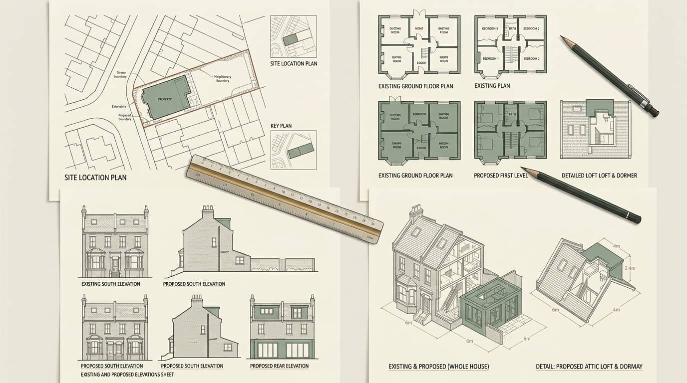
The full drawing set for a Basildon application — location and block plans, existing and proposed floor plans, elevations and sections, drawn to West Berkshire Council's validation checklist so the pack is accepted first time, delivered in days and revised free until your decision, with a free approval-odds check first.
West Berkshire Council granted 93% of the householder planning decisions it made in its latest published year — 6 points above the 87% England-wide householder average. Basildon contains Aldworth, Ashampstead, Lower Basildon conservation areas (Aldworth designated 1970), so materials, fenestration and roof form are assessed against the appraisal, which is where a policy-literate drawing pack earns its keep. Its dominant Victorian (1837–1901) and postwar (1945–1970) housing stock sets the design brief on most streets.
Under Class B, a rear dormer stays permitted development up to 40m³ of added roof volume on a terrace or 50m³ on a semi-detached or detached house, while Class A allows a single-storey rear extension of 3m beyond the original rear wall on a terrace and 4m on a detached house before a full application is needed. Basildon carries at least one Article 4 direction, and conservation areas including Aldworth, Ashampstead and Lower Basildon remove those rights outright, so we confirm your exact address before a line is drawn. A validated householder application in Basildon is determined against an 8-week statutory target.
Aldworth (conservation area designated in 1970), Ashampstead (conservation area designated in 1971), Lower Basildon (conservation area designated in 1971), Streatley (conservation area designated in 2010), Aldworth (civil parish within Basildon), Ashampstead (civil parish within Basildon) and Streatley (civil parish within Basildon) — these are the Basildon pockets our drawings cover most. Heritage designations here include Aldworth, Ashampstead, Lower Basildon and Streatley. West Berkshire Council weighs each proposal against the adopted West Berkshire local plan and West Berkshire Council's design guidance for householder work, where the 1,300 homes here are 22% pre-1900, 11% 1955-1964, 11% 1965-1972, which is what sets the realistic roof and rear-projection options. On roofs the borough is steeply pitched slate roofs, valley gutters and party parapets typical of pre-1900 building and shallow gabled roofs typical of that period's building, over Victorian and earlier houses (22% of 1,300 homes), late-1950s and early-1960s houses (11%) and late-1960s and early-1970s houses (11%).
Basildon's designated heritage is specific, and it is the first thing we check against your address: Aldworth (conservation area designated in 1970), Ashampstead (conservation area designated in 1971), Lower Basildon (conservation area designated in 1971) and Streatley (conservation area designated in 2010). Inside those boundaries permitted development is curtailed and West Berkshire Council assesses materials, window detail and roof form against the area's own appraisal, so a scheme that would be waved through two streets away can need a full application here.
Beyond the designated areas, Basildon takes in Aldworth, Ashampstead and Streatley. West Berkshire Council has 9 recorded Article 4 directions — check the address before assuming PD applies in Basildon.
On stock, Basildon is Victorian and earlier houses (22% of 1,300 homes), late-1950s and early-1960s houses (11%) and late-1960s and early-1970s houses (11%) — which is why steeply pitched slate roofs, valley gutters and party parapets typical of pre-1900 building and shallow gabled roofs typical of that period's building govern what a loft or rear projection can realistically be. West Berkshire Council decided 606 householder applications in the latest published year and granted 93%, with 57% issued inside the eight-week target. Those are the numbers our drawings are prepared against.
The full build-period split for Basildon runs pre-1900 22% (280 homes), 1900-1918 8% (100 homes), 1919-1929 2% (30 homes), 1930-1939 6% (80 homes), 1945-1954 9% (120 homes), 1955-1964 11% (140 homes), 1965-1972 11% (140 homes), 1973-1982 5% (70 homes), 1983-1992 5% (70 homes), 1993-1999 3% (40 homes) and 2000-2008 10% (130 homes). That distribution is why pre-1900 detailing dominates the drawings here, and it is measured from council-tax records rather than assumed from the street name.
West Berkshire Council also decides for Aldermaston, Bradfield, Chieveley & Cold Ash, Downlands, Hungerford & Kintbury, Lambourn, Newbury Clay Hill and Newbury Greenham, so a decision in Basildon sits inside a wider pattern of decisions we track across the same authority — useful when an officer cites a precedent from the next area over.
The Article 4 directions recorded for this council include Fords Farm Estate, Land Fronting 1085-1107 Oxford Road, Tilehurst, Land at East Garston and Land at Theobald Drive, Tilehurst. Each removes a specific permitted-development right inside its own boundary, which is why the check is done on the address rather than on the town.

Published figures for Basildon and West Berkshire Council. These are the numbers that decide what is realistic on your street, so we work from them rather than from national averages.
| Measure | Basildon |
|---|---|
| Dwellings recorded | 1,300 |
| Built pre-1900 | 280 (22%) |
| Built 1900-1918 | 100 (8%) |
| Built 1919-1929 | 30 (2%) |
| Built 1930-1939 | 80 (6%) |
| Built 1945-1954 | 120 (9%) |
| Built 1955-1964 | 140 (11%) |
| Built 1965-1972 | 140 (11%) |
| Built 1973-1982 | 70 (5%) |
| Built 1983-1992 | 70 (5%) |
| Built 1993-1999 | 40 (3%) |
| Built 2000-2008 | 130 (10%) |
| Built before 1919 | 29% |
| Built 1919–1939 | 8% |
| Built 1945–2008 | 55% |
| Conservation areas in Basildon | 4 (Aldworth, Ashampstead…) |
| Conservation areas district-wide | 51 |
| Article 4 directions recorded | 9 |
| Householder applications decided | 606 |
| Householder applications granted | 93% |
| Decided within 8 weeks | 57% |
Dwelling stock from VOA council-tax data at 31 March 2025; conservation-area and Article 4 counts from planning.data.gov.uk (MHCLG); decision figures are West Berkshire Council's own, from MHCLG live table PS2 for the year to 31 March 2026.
Whatever you are building, West Berkshire Council decides it from the same core set. A location plan at 1:1250 fixes the site on the map with the red-line boundary; a block plan at 1:500 shows the property in its plot; then existing and proposed floor plans and elevations at 1:100 or 1:50 show the house as it is and as it will be. Larger schemes add a section and, where policy requires, a design and access statement. Miss one and the application is returned invalid before an officer has looked at it.
The drawings are also the argument. West Berkshire Council assesses each proposal against the adopted West Berkshire local plan and West Berkshire Council's design guidance for householder work, and the elevations are where the case is won or lost — ridge and eaves heights, window positions, materials and how the change reads from the street. On Basildon's stock, which runs to Victorian and earlier houses (22% of 1,300 homes), late-1950s and early-1960s houses (11%) and late-1960s and early-1970s houses (11%), the same scheme is drawn differently to answer the concerns officers raise here. Basildon contains Aldworth, Ashampstead, Lower Basildon conservation areas (Aldworth designated 1970), so materials, fenestration and roof form are assessed against the appraisal, so the pack is built to pre-empt exactly that.
Where the property sits in a conservation area — Aldworth, Ashampstead, Lower Basildon and Streatley among Basildon's — validation is stricter still, often demanding heritage detail and sometimes additional plans. West Berkshire Council has 9 recorded Article 4 directions — check the address before assuming PD applies in Basildon. We confirm the designation before drawing so the pack meets the higher bar first time.

West Berkshire Council validates against a published checklist before it assesses anything. A typical householder application needs each of these, correctly scaled and labelled:
We draw the complete set — location and block plans, existing and proposed plans, elevations and any section — to West Berkshire Council's checklist, then lodge it on the Planning Portal, manage validation and answer case-officer queries so the application is decided on its merits, not bounced on a technicality.
Below is West Berkshire Council's real householder decision record, drawn from official planning statistics and refreshed as new data lands. West Berkshire Council granted 93% of its householder applications in the year to 31 March 2026, and Aldworth shapes what is approved here. A complete, correctly scaled pack that answers those concerns on the elevations is validated faster and refused less often than one that leaves them for the officer to raise.
Source: MHCLG planning application statistics (householder decisions, England, 1 April 2025 - 31 March 2026). Compare every borough on our London approval-rate league table.
Tell us about your project and get a fixed, no-obligation quote back within one working day. If you don't need planning permission at all, we'll tell you that too — for free.
Two different things sink an application, and they happen at two different stages. First is validation: a missing block plan, an unscaled elevation, no red line, no north point — West Berkshire Council returns the whole submission and the clock never starts. Getting the pack right at this stage is purely mechanical, and it is where a lot of self-submitted Basildon applications lose weeks. We draw to the checklist so this never happens.
Second is the planning judgement itself, once the pack is valid. The 1,300 homes here are 22% pre-1900, 11% 1955-1964, 11% 1965-1972, which is what sets the realistic roof and rear-projection options. Across Aldworth, Ashampstead and Lower Basildon the recurring refusals are about scale, overlooking and how the proposal sits against its neighbours — all of which are settled on the drawings. We draw the scheme to answer them before submission rather than after a refusal.

The application pack is the same discipline whatever the project. A few of the Basildon neighbourhoods and property types we prepare drawings for most often:
Planning drawings for Aldworth's conservation area designated in 1970 — scaled, validation-ready and drawn to West Berkshire Council's guidance.
Planning drawings for Ashampstead's conservation area designated in 1971 — scaled, validation-ready and drawn to West Berkshire Council's guidance.
Planning drawings for Lower Basildon's conservation area designated in 1971 — scaled, validation-ready and drawn to West Berkshire Council's guidance.
Planning drawings for Streatley's conservation area designated in 2010 — scaled, validation-ready and drawn to West Berkshire Council's guidance.
Planning drawings for Aldworth's civil parish within Basildon — scaled, validation-ready and drawn to West Berkshire Council's guidance.
Planning drawings for Ashampstead's civil parish within Basildon — scaled, validation-ready and drawn to West Berkshire Council's guidance.
The route decides what West Berkshire Council needs and how long it takes. This is how the common Basildon routes compare.
| Route | When it applies | Core drawings | Typical decision |
|---|---|---|---|
| Householder application | Extensions and alterations to a single house | Location, block, existing & proposed plans and elevations | About 8 weeks |
| Full application | Flats, new units, changes of use | As householder plus site plan and often a section | 8–13 weeks |
| Lawful development certificate | Confirming a scheme is permitted development | Existing & proposed plans and elevations to prove PD limits | About 8 weeks |
| Prior approval | Larger single-storey rear extensions | Plans and elevations plus neighbour notification | About 6 weeks |
In a conservation area such as Aldworth and Ashampstead, householder permitted-development rights are often restricted, so a full application and heritage detail may be required.
A fixed process built around how West Berkshire Council validates and decides — most drawing sets are submission-ready within seven days of survey.
Send us your Basildon postcode and what you want to build. We confirm your conservation and Article 4 status, tell you which application route applies, and score your odds against live West Berkshire Council decisions.
We measure the property and plot so the existing plans and elevations are accurate to the millimetre — the base every proposed drawing and every officer judgement is built on.
Chartered designers produce the full validation pack — location and block plans, existing and proposed plans, elevations, any section and a design and access statement — drawn to West Berkshire Council's checklist.
We lodge the application on the Planning Portal, manage validation and case-officer queries, and revise the drawings free until West Berkshire Council issues its decision.
West Berkshire Council validates a householder application against a set list: a location plan at 1:1250 with a red-line boundary, a block plan at 1:500, and existing and proposed floor plans and elevations at 1:100 or 1:50, each with a scale bar and north point. Larger schemes and most conservation-area work also need a design and access statement. If any of these is missing or unscaled the application is returned invalid before it is assessed. This applies to your Basildon address specifically.
Almost always because the drawing pack is incomplete or wrongly scaled — a missing block plan, an elevation with no scale, no red line on the location plan, no north point. West Berkshire Council checks the pack against its validation list before an officer ever assesses the scheme, so these purely technical gaps cost weeks. Drawing to the checklist from the outset is the simplest way to avoid a return. This applies to your Basildon address specifically.
Yes. We prepare the full drawing set, lodge it on the Planning Portal on your behalf, pay the West Berkshire Council fee where you prefer us to, and then manage validation and case-officer questions through to the decision. You get the reference number and updates without dealing with the portal or the council yourself. This applies to your Basildon address specifically.
A householder application is a statutory eight weeks from validation, and a full application eight to thirteen weeks depending on scale. The date that matters is validation, not submission — an invalid pack never starts the clock. Because we draw to West Berkshire Council's checklist the application validates quickly, so the statutory period begins without the delay a returned pack causes. This applies to your Basildon address specifically.
You do not strictly need a planning application, but scaled existing and proposed drawings are still worth having: a lawful development certificate from West Berkshire Council proves the scheme is permitted development, which lenders and buyers increasingly ask for, and your builder needs the drawings to price and build. In a conservation area such as Aldworth and Ashampstead, permitted-development rights are often removed, so a full application may be needed after all — we confirm which before you commit. This applies to your Basildon address specifically.
We price each Basildon job individually — the scope of the survey and the size of the drawing set vary from a simple rear extension to a whole-house scheme — and send a fixed, no-obligation quote within one working day. It covers the full validation pack with free revisions until West Berkshire Council decides. The West Berkshire Council application fee is separate and paid to the council. Call 020 7864 7245 to start.
Answer five quick questions and get a free planning score for your exact address — instantly. Then, if you want the full picture, unlock the detailed analysis: your council's live approval rates, local precedents, constraints on your street and a step-by-step route to permission.
Same fixed quotes, same fast drawings — wherever your project is.